Exploring Mars Surface – 3D Visualization of post processed MARSIS data
Project reference: 1506
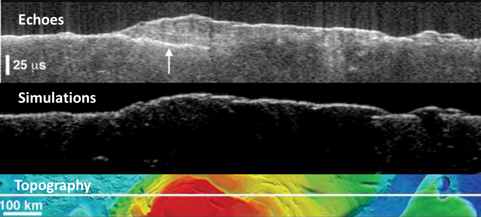
MARSIS is a radar carried by the European Space Agency spacecraft Mars Express, and probing the interior of Mars to look for ice and water. To validate identification of echoes from subsurface structures, electromagnetic scattering from the Martian surface was simulated using HPC. Simulations will make it possible to use automated procedures to detect subsurface interfaces, or to study the correlation between real and simulated surface echo strengths to detect unusual surface properties.
In the framework of the PRACE Summer of HPC program we plan to create some 3D stereoscopic videos of the Mars surface, and only for some areas (e.g. Mars’ Poles) analyze subsurface structures. All this materials will be public available on the CINECA website.We also plan to create an automatic procedure to interactively visualize the data. This procedure could help researchers to found some relevant structures under Mars surface.
Project mentor: Roberto Orosei
Site Co-ordinator: Massimiliano Guarrasi
Learning Outcomes
Manage parallel applications for 3D visualization. Increase student’s skills on parallel computing. Manage astrophysical and geological dada.
Student Prerequisites (compulsory)
MPI, Blender, Paraview, Python, C/Fortan
Student Prerequisites (desirable)
OpenSceneGraph, QGIS or other GIS software, Knowledge in Earth science
Training Materials
none
Workplan
- Week 1: Introduction to CINECA systems, and small tutorials on parallel visualization
- Week 2: Assess modifications needed for the reading in and interpretation of datasets and the additional functionality required to output movies
- Week 3: Deliver Plan at the end of week
- Week 4, 5, 6: Production phase.
- Week 7:Preparation of the final movie
- Week 8: Preparation of the final movie. Write the final Report.
Final Product Description
Some 3D stereoscopic videos will be made. The obtained results and the work done during the project will be showed in a movie and described in a small paper.
Adapting the Project – Increasing the Difficulty
If it is compatible with the working plan and with the skills of the student, a 3D interactive web application (similar for example to Google Earth application) will be created in order to visualize Mars surface.
Adapting the Project – Decreasing the Difficulty
If some issues arise, we will reduce the number of the movie that the student will have to produce.
Resources
The students will have access to PICO and GALILEO clusters. If necessary also an access to the FERMI cluster will be given. All the material needed for the project (both software and hardware) will be given by CINECA.
Organization
CINECA
![]()
