Check out my new results using Machine Learning.

Satellite-derived bathymetry using machine learning and optimal Sentinel-2 imagery in South-West Flo
Check out my last results with machine learning.
In my previous posts I introduced my work mapping the seabed in the Calabrian Sea. Just a few weeks ago I succeed mapping this Sea using one algorithm that uses band ratios to estimate depth. I shared you this map in my last blog and I promised you that I would start working on the same but using machine learning (ML) and I will show you the results. So, here you have the results and a briefly explanation of the computational process.
The process
I worked in the same area covering bathymetry up to 20 meters. I used only the 80% of one satellite image to train the regressor and I tested the model with other images. But this time I considered other variables (See figure 1) such colour bands and pSDB ratios.
Between all ML methods I chose Random Forest (RF) because it´s a popular method to estimate the importance of the input variables. I did several test using different combination of features and I found out that the most important features are the colour bands blue, red, green and near infrared, and the most important ratios are those between blue and green, blue and red or blue and near infrared. If we add any other features of the table, we will not improve the result and we will expend more time for training the model.
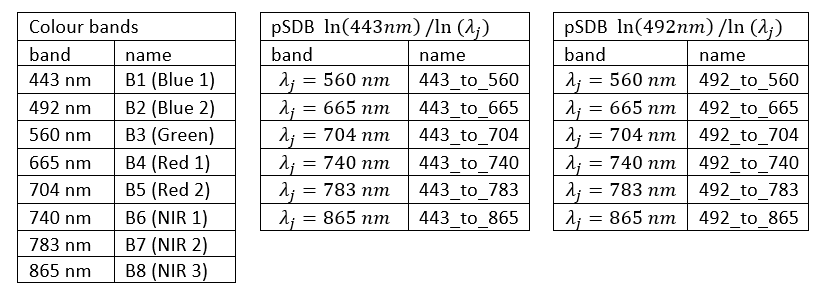
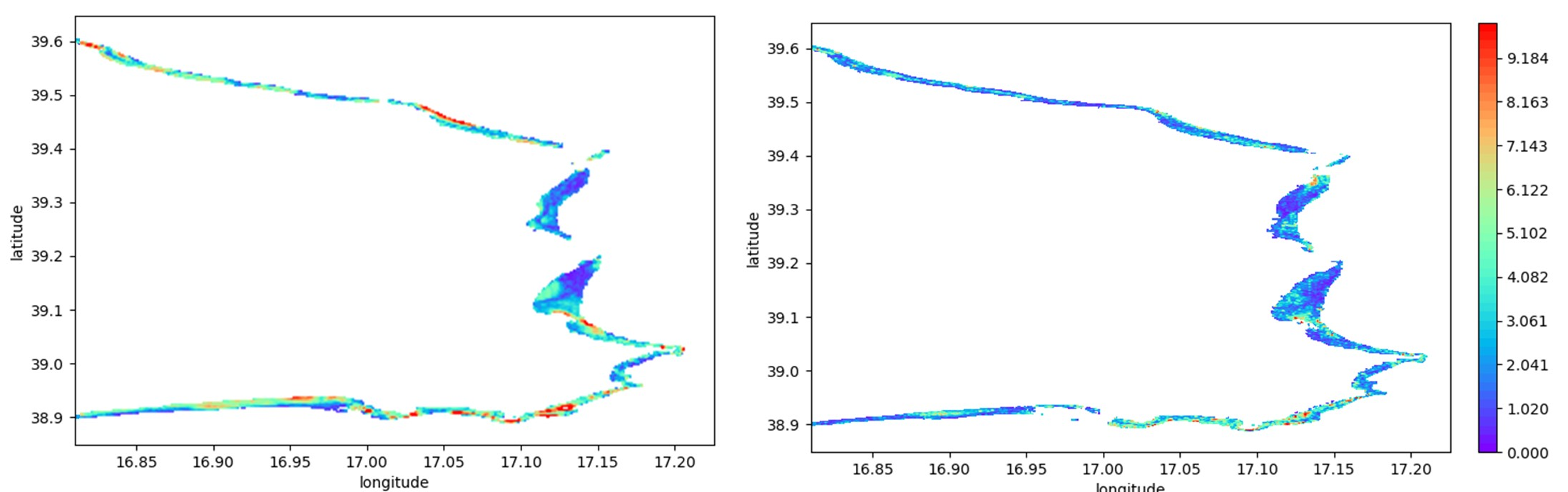
We found out that ML gives better results than the last ratio algorithm getting images with lower errors. In the next figure I compare the absolute error for pixel for images treated with the ratio´s algorithm (see last post) and ML. We see directly that ML gives better results.
Conclusions
During this internship we have proven that satellite imagery can be used to estimate bathymetry. We have tested two algorithms to estimate bathymetry data, ML and the ratio´s algorithm of my last post. We found out that ML gives better results.
Moreover, we saw that ML can give us the relative importance of different variables. That makes ML good approach to new problems, because it can tell us what variables are more useful to solve the problem.
Unfortunately, summer ends and the internship is over. I hope that you learned something and if you have any doubt, please let me know.
Best regards,
Román

Leave a Reply