A virtual journey – from vienna – over UK supercomputer – to MPAS earth atmosphere modelling

After this two month being part of the PRACE Summer of HPC, contributing to the MPAS (Model Prediction Across Scales) together with Jonas Eschenfelder, I not only learned how to run MPAS atmospheres, on the national Supercomputer: ARCHER2, how to investigate performance of simulation runs, depending on the cores and set-ups like simulation time and physical parameters, and how to process the output to visualize them with python, but also experiencing how well this remote collaboration across Europe with our project mentors Evgenij Belikov and Mario Antonioletti from the EPCC in Edinburgh and with my project partner Jonas Eschenfelder from the Imperial College London, worked out.
At the beginning, the excitement about having the possibility to work on ARCHER2, and to run a new atmosphere model on this Supercomputer, where over the top – also when there came some installation and set-up problems up, I was always optimistic overcome those, because the hope, that after break down this barriers the results will be worth the persistence. And it has proven true – we were not just able to run performance tests, but also write an visualisation script in python. The latter process was my favourite part of our project, and thereforeI will shortly describe the steps to get this visualisation script.
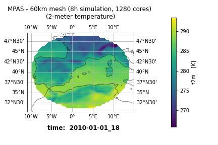
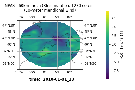
As an output from the MPAS simulation runs, we get this compressed netCDF files, I plottet the containing physical parameters directly to a sphere (see also my second post blog for that). But in this script it was necessary to differ between the different locations (cell, vertex, edge). But there is the possibility to transform this three different locations to longitude and latitude, and then you have a consistent connection between the output parameters and the locations. Furthermore it is easier using common python maps, like Cartopy, to plot them in the Background for a better orientation. Not only for global simulations, but especially for regional simulations, see figures below.
During PRACE Summer of HPC, I not only learned a lot of new skills, it was also enriching on a personal level and made me more self-confident – because experiencing the success when you work on things, which are for you completely new, but you stay tuned to, I am sure, will also encourage me for future projects.
