This one weird algorithm can understand seabed reliefs!

Hi everyone! It’s Raska again here with a quick update on our Summer of HPC project. I gave little outline in my previous blog post (if you haven’t seen it, check it out here: (Machine) Learning How to Sea) and gave a quick intro on supercomputers. We’ve learned that they are essentially computers that work together to solve problems – here, we’ll discuss what specific problem we’re trying to tackle.
What’s the project about?
Me and Mario are trying to develop a computer program which uses artificial intelligence methods to automatically detect and classify reliefs in the sea, such as underwater mountains, trenches, canyons, and more. The method will be able to take in images of the deep sea and estimate what reliefs exist in the area.
All seabed maps in this article have been acquired by OGS (Instituto Oceanografia e Geofisica Sperimentale – Institute of Oceanography and Experimental Geophysics), under the framework of the MaGIC project (Marine Geohazards along the Italian Coasts) which was funded by DPC (Dipartimento della Protezione Civile – Department of Civil Protection)
Why are we doing the project?
In this project, we specifically focus on reliefs near coastal areas, because they are probably the most important part of the sea. Not only are they close to cities, coasts have a lot of marine biodiversity, and can their seabeds can contain important communications, power, and gas lines that these cities need. Coastal reliefs must be mapped out as it gives us an idea of what processes might happen under the sea, such as landslides and earthquakes. Knowledge of the likelihood of these processes can help us preempt and reduce their detrimental impact to such undersea assets, but most importantly to preserve the regional marine ecosystem.
Typically, these reliefs are classified and lineated manually. In other words, a team of marine geologists will look at a map of the sea and identify and mark out what reliefs exist in the region. This is a long task which requires the geologists to have a mutual understanding of all the relief characteristics. Because of this, we’re limited to how much information of the sea we can understand. However, an automated method can save time and also improve throughput; we’ll be able to classify more areas of the sea.
How does it work?
In our project, we use computer vision methods (a branch of artificial intelligence), which concerns how computer systems can interpret and understand images and videos. These methods can have a lot of daily uses; from recognising license plates of speeding cars to even facial detection for your holiday photos on Facebook! Much like teaching the names of objects to a human, we need to ‘teach’ the computer what each relief looks like, so in this case we need to use labeled ‘teaching material’ (in AI, we call this a training dataset).
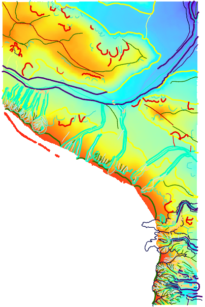
A few years ago, a bunch of scientists involved in the Italian MaGIC project got together and went on huge boats equipped with measuring equipment to obtain relief maps of the Mediterranean sea. Their observations were then mapped and classified manually. Thanks to their effort, we now have labeled digital maps of the Italian coasts, which we now use as our training dataset as seen in image [2].
The algorithm we are using is a type of Convolutional Neural Network (CNN) – if you are not familiar with these, all you need to know is that they’re an artificial intelligence algorithm inspired from how humans perceive sight. CNNs are common in image and video recognition; here, we use them to recognise ‘images’ of the seabed. Bear in mind, these ‘images’ aren’t just pictures of the sea; these are mappings of the measurements done by the scientists in the MaGIC project.
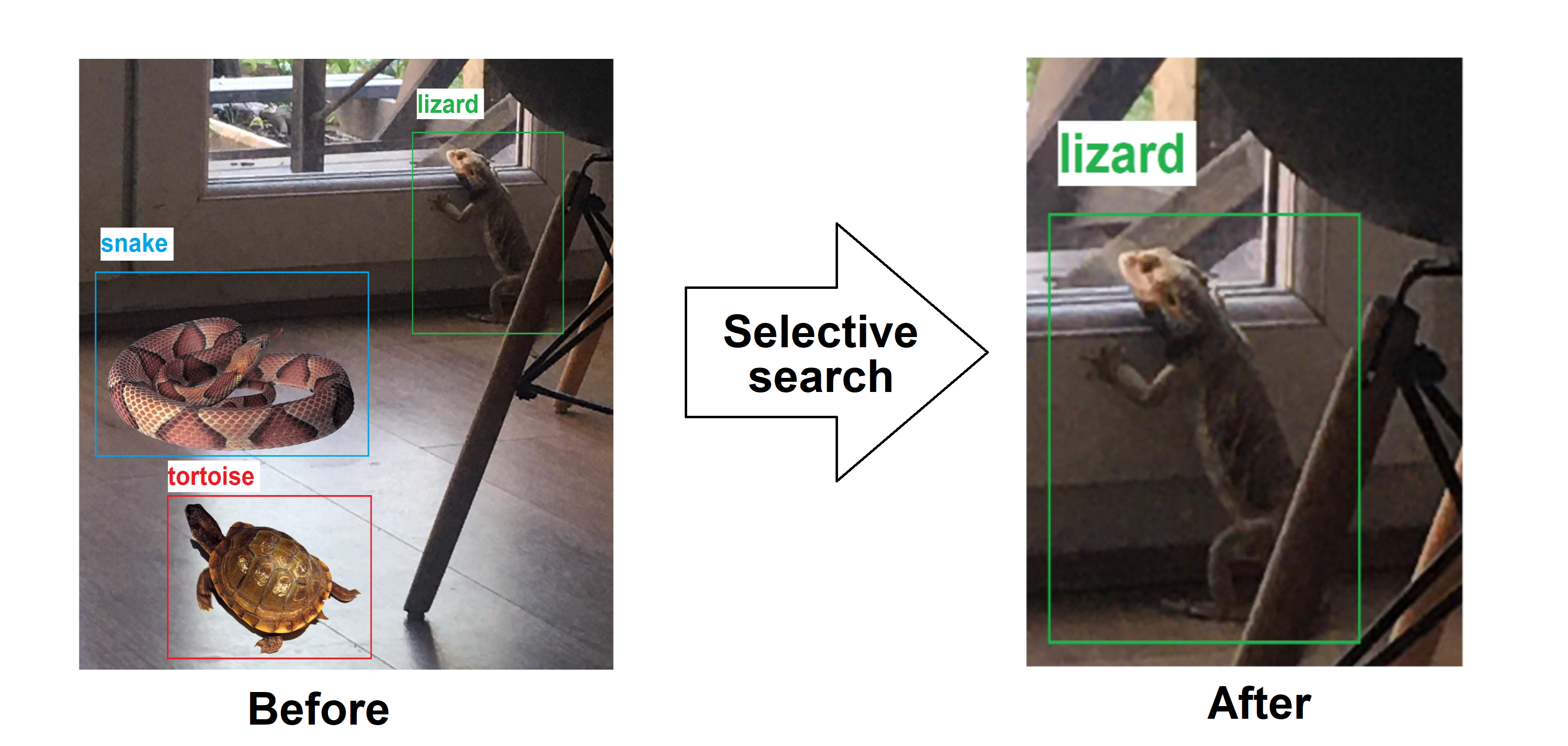
We ‘cut’ these images into small parcels that are each labelled as one specific type, in a process called Selective Search. Again, same like teaching to a human, if we wanted to teach someone how to differentiate between lizards and other reptiles, we’d ideally like to show it a good image of what it looked like, preferably without any other reptiles around it, to avoid confusion.
We then feed these labelled images into our algorithm so that it can update itself until it meets a satisfactory accuracy level – this is called training a model. The dataset we generated is massive, and our CNN is also heavy to calculate, therefore we need a lot of computing power. This is why we are using Marconi100, the main supercomputer at CINECA. At the moment, it’s the 14th most powerful computer in the world!
Our buddy Marconi100 has helped with generating the dataset from the labeled maps and setting up preliminary models. This third member of our team is powerful enough (and possibly much smarter than me and Mario combined) to run our program, as it uses a method called parallel computing – this means that certain sections of the program is run together by different components of the computer, making it much quicker than running using one device.
How is the project going?
Pretty good, I think! We’ve had a few hiccups dealing with converting the data from GIS files (Geographic Information Systems – a type of software used by geologists to analyse map data) into a good format for our model, but we’ve now trained some models with varying accuracy, using a single patch of map from the MaGIC project. We still think there is more we can do to improve it until we’re certain we want to deploy our model to predict larger areas, such as the entire MaGIC repository.
A little question before we go:

Last time, we discussed what supercomputers can be used for – I was really glad to see your enthusiasm for supercomputing. Here, we’ve learned how we can use artificial intelligence, specifically computer vision, to detect undersea reliefs. Besides this, AI methods come in a lot of forms for different functions. So, my questions are:
What do you think AI can do?
What comes into mind when you hear the phrase Artificial Intelligence?
Leave your answers in the comment section below!
Image references
[1] Coastal reliefs – Encyclopaedia Brittanica
[2] Patch of Calabrian coast – Istituto Nazionale di Oceanografia e di Geofisica Sperimentale
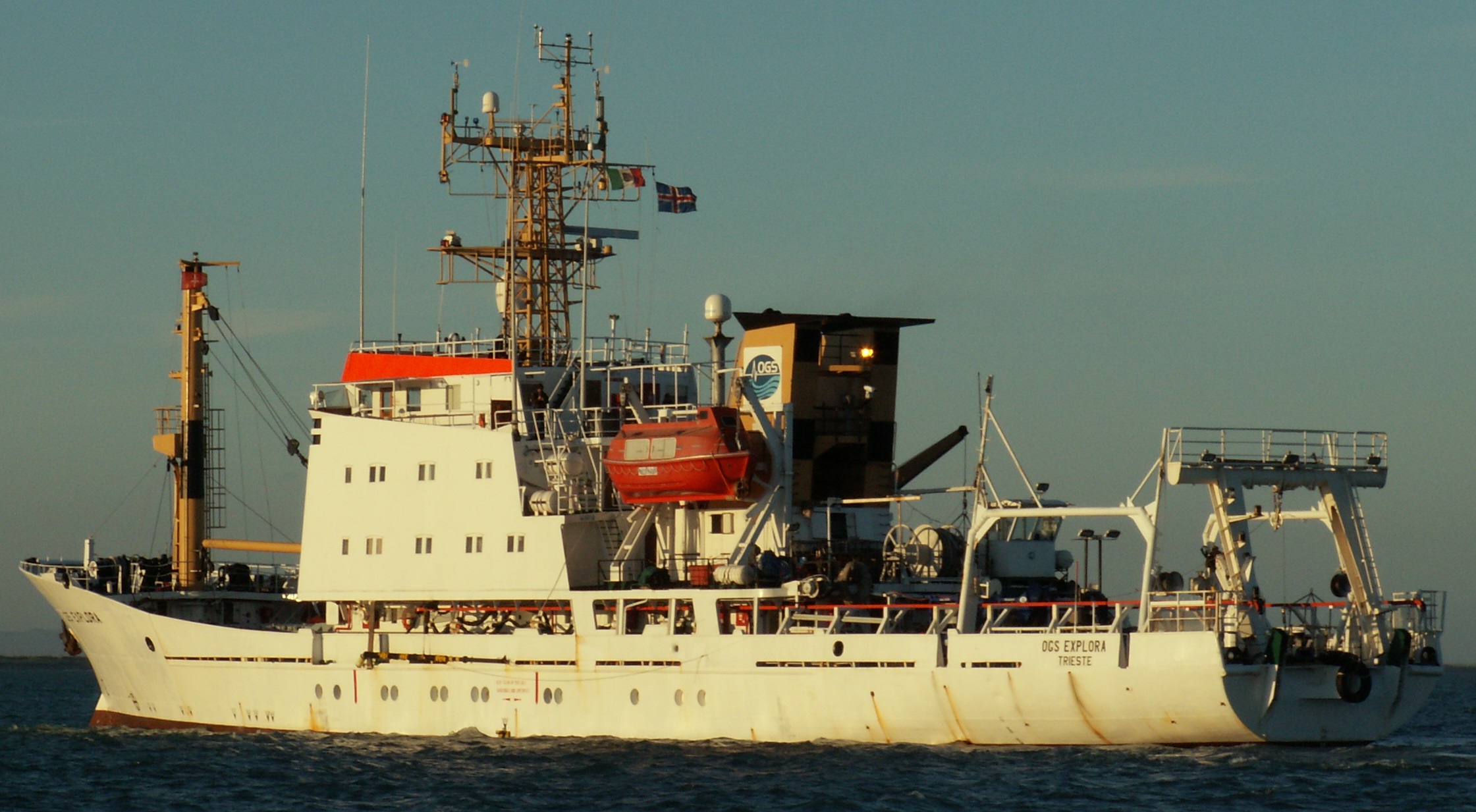
[3] OGS Explora – Istituto Nazionale di Oceanografia e di Geofisica Sperimentale https://www.inogs.it/en/content/research-vessel-ogs-explora
[4] Selective search – Authors own image, also using images from https://pngimg.com/image/4065 and https://www.schoolphotoproject.com/animals/tortoise-photo5.html
[5] Free question stock photo – FreeImages https://www.freeimages.com/photo/question-1239547

It’s times like this that makes me miss learning science 🙁 Good luck Raska and Mario!
Thank you Audrey!! Best of luck to you too : )
Interesting read, Raska. AI is definitely not as ‘techy’ or (videogame-like) ‘vile’ as some people might think but they’re certainly useful tools in solving modern problems. I for one am excited for its potential in examining complex flows in the human organs. I think It’s truly exciting how we can potentially solve high-fidelity models of the fluid on a human system to understand better what’s going on inside our body! With AI, maybe our deeper understanding of some complex problems can lead to us saving more lives.
That’s true! AI is far from being ‘truly intelligent’ in the sense that there is still a lot of human intervention in ensuring the algorithm outputs the right things we want. However, we have definitely come quite far! A range of specialised machine learning tools & packages have become more accessible, making it way more easier these days to generate solutions to problems such as fluid flows in the human body!
Great to read about your PRACE Summer of HPC work! Keep posting!
Thanks Lee!!